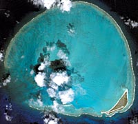
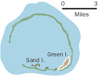
Kure Atoll
Other names: Mokupapapa, Ocean Island, Cure.
Geography: Northwesternmost of the Northwestern Hawaiian Islands. Lagoon forms a near-circle
Distance from Honolulu: 1,380 miles
Highest point: 20 feet
Type of island: Atoll — the northernmost atoll in the world
Acreage dry land: 320 acres (Green Island only. Neighboring Sand Island comes and goes)
Coral reef within 13.8 miles: 79,972 acres
History: Site of several shipwrecks in 1800s. U.S. Navy built tall radar reflector in 1955. Coast Guard navigation radio station operated from 1960 to 1992, when Green Island runway was allowed to be overgrown. Unlike all the other Northwestern Islands, which are under federal control, Kure is a state wildlife sanctuary.
|
|
|
The Banks >> |