|
Advertiser Staff
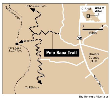
LOCATION: The trailhead is in Kunia, near the Hawai‘i Country Club. From Honolulu, take the H-1 Freeway west toward Wai‘anae to Exit 5B. Drive north on Kunia Road (Route 750), passing the Hawai‘i Country Club on the right. At the next rise, bear left on a dirt road paralleling the highway and turn left on the second dirt road heading toward the mountains. When the road reaches the forest line, park at the edge of the woods, off the roadway (the road continues to the right). Look for the trail, which begins at the edge of the woodline.
DESCRIPTION: This exhilarating 4-mile round-trip adventure in the Wai‘anae mountains reaches the summit of O‘ahu’s third highest peak in a surprisingly short two hours. While most of the climb is along a wooded trail, there are some exposed ridge sections that are not suitable for acrophobes or young children. Although the climb begins gradually, after about 30 minutes the trail steepens and becomes a relentless upward grind, with no switchbacks to smooth out the grade. The final portion is particularly steep, requiring arms as well as legs, and using roots, small trees, and a short, fixed rope for assistance.
From the trailhead, after walking a short distance into the woods, a sign announces entry into the Honouliuli Preserve (by permit only, see below), and the trail winds upward through mainly introduced trees and plants, including coffee and macadamia. After about 15 minutes, it reaches an intersection with the Honouliuli Contour Trail, a wide, generally level route connecting Kolekole Pass to Palehua. A left turn onto the contour trail brings a more relaxed stroll for another 15 minutes, until a smaller trail takes off sharply uphill on the right, at a point where the contour trail is about to cross a dry streambed.
From here, the trail heads straight up, becoming progressively steeper, except for two short almost level portions along the ridge line. After passing through a partly open clearing, the ridge narrows considerably, and care must be taken on the exposed portions. As the trail climbs, it reveals a dramatic view of the east wall of Pu‘u Kaua and the precipitous peaks on its flanks. A final pull upward and the trail breaks out onto the flat, grassy summit of Kaua (3,127 ft.).
The reward is a sweeping 360-degree view over O‘ahu, reaching from Diamond Head to the North Shore, and from the Wai‘anae coast to the Ko‘olau mountains across the Schofield plain. It is the perfect spot for lunch. Return via the same route.
SPECIAL COMMENTS: Permits for this hike are required from Del Monte Corp. (621-1201), and The Nature Conservancy (537-4508). Because permits are not normally given to individuals, this hike is best done with a group, such as the Hawaiian Trail and Mountain Club (674-1459) or the Sierra Club (573-4147), which regularly schedule the hike.
[back to top] |
|